Final advisory check
What the final Bertha advisory actually says
- Official status
- Dissipated after opening into a trough
- Final location
- About 40 miles west-northwest of Houston, Texas
- Final sustained wind
- 35 mph, with higher gusts
- Final movement
- West at 14 mph
- Coastal warnings
- None in effect in the final NHC advisory
- Rain forecast
- 1 to 3 inches in South Texas, isolated totals to 4 inches overnight
- Remaining concerns
- Isolated flash flooding, elevated water, dangerous surf and rip currents
- Live information
- Local National Weather Service warnings and emergency authorities
This is a time-stamped explanation, not a live warning service. Use weather.gov and local authorities for current conditions.
The final advisory used a more precise word than “weakened”
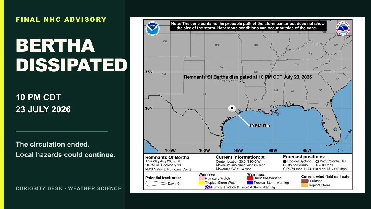
At 10 pm Central Daylight Time on 23 July 2026, the National Hurricane Center issued advisory 19 for the remnants of Bertha. Surface observations over eastern Texas showed that the storm no longer had a well-defined circulation. It had opened into a trough, so the centre declared the system dissipated and ended its advisories.
That is more specific than saying Bertha became a weak tropical storm. A tropical cyclone needs a closed circulation around a centre. Once that circulation is gone, the weather may continue, but the organised tropical cyclone no longer exists. Bertha’s name therefore stopped describing an active cyclone even while some of its moisture and wind effects remained.
“Remnants” is not always the same as a “remnant low”
People often use remnants as a general word for everything left after a storm loses its tropical status. The official term remnant low is narrower. National Weather Service guidance defines it as a post-tropical low that lacks the thunderstorm organisation of a tropical cyclone, has sustained winds below tropical storm strength and still retains a low-pressure circulation.
Bertha’s final discussion did not classify it as a continuing remnant low. It said the circulation had opened into a trough. A trough is an elongated area of relatively low pressure rather than a closed swirl. The distinction sounds technical, but it explains why the final map marked a position while also stating that the system had dissipated.
A storm can end before all of its hazards do
A tropical cyclone is a particular organisation of wind and pressure. Rainfall, waves and thunderstorms do not disappear the instant that organisation breaks down. Moist air can keep rising along a trough, individual thunderstorms can retain strong gusts, and swells created earlier can continue travelling toward a coast after the centre is gone.
The final Bertha advisory expected 1 to 3 inches of rain over South Texas during the night, with isolated totals to 4 inches. It warned that isolated flash flooding was possible, especially in urban areas. It also said coastal water levels could remain elevated through the next high-tide cycle and that dangerous surf and rip currents could continue along the Louisiana and Texas coasts.
Why a 35 mph wind did not keep Bertha alive
The final advisory still listed maximum sustained winds near 35 mph. Wind speed alone does not decide whether a system remains a tropical cyclone. Forecasters also look for a closed low-level circulation and organised deep convection, the clusters of strong thunderstorms that help a tropical cyclone maintain its warm-core structure.
A windy shower, a gust front or a pressure trough can produce strong local winds without being a tropical cyclone. In Bertha’s case, surface observations showed that the essential closed circulation had disappeared. The number beside maximum wind described the strongest remaining flow, not proof that an intact depression still existed.
The cone never showed the full hazard area
The black box at the top of the National Hurricane Center’s final graphic carries an important warning: the cone shows the probable path of the storm centre, not the size of the storm. Hazardous conditions can occur outside it. This is true while a cyclone is active and remains useful when looking back at the final map.
Rain is often displaced from the centre by wind shear, land interaction and the storm’s uneven structure. Earlier on 23 July, the Houston and Galveston forecast office described Bertha as poorly organised, with most persistent thunderstorm activity pushed south of the circulation. A centre point near one town therefore could not describe where every downpour or gust would occur.
The last NHC advisory does not cancel every local product
The National Hurricane Center ends tropical cyclone advisories when the system no longer meets the definition or no longer needs that national product. Local National Weather Service offices can still issue flood warnings, rip-current statements, marine advisories, heat alerts and ordinary forecasts for conditions left behind or arriving next.
That handoff prevents a misleading all-clear. In the hours around Bertha’s dissipation, the Houston and Galveston office was still tracking lingering showers and thunderstorms, marine winds and hazardous beach conditions. The exact list changes quickly, which is why an archived tropical advisory should never replace the live forecast for a reader’s location.
Rainfall danger is not ranked by the storm’s final category
The Saffir-Simpson categories describe maximum sustained wind in a hurricane. They do not rank rainfall or flood danger. The National Hurricane Center says inland flooding is a major tropical-cyclone threat, and a weaker or decaying system can still produce serious rain if moisture repeatedly crosses the same area.
Movement and track matter as much as the label. A fast, intense storm may pass one place quickly, while a weaker system or leftover trough may keep feeding thunderstorms into a small corridor. Local soil saturation, drainage and urban surfaces then help decide whether the same rainfall total becomes manageable runoff or a flash flood.
Old storm graphics become misleading surprisingly fast
A screenshot preserves the forecast and warnings from the moment it was made. It does not update when the circulation shifts, a watch expires or the cyclone dissipates. Sharing an old cone without its advisory number and time can make readers believe that a superseded forecast is still current.
For Bertha, the final official cone is useful evidence of how the cyclone ended. It is not a live map for travel on 24 July or later. Anyone checking conditions should start with the current National Weather Service page, enter the relevant location and read active warnings before using an archived image for context.
Use three layers of information, in this order
First, use local warnings and emergency instructions for decisions. The weather.gov forecast for a town or postcode points to active warnings from the responsible forecast office. Road closures, evacuation messages and beach restrictions may come from local authorities and can remain in force after a storm name disappears.
Second, use the National Hurricane Center for the cyclone’s official history and final status. Third, use rainfall, radar and river products to understand hazards that no longer fit neatly inside a tropical advisory. This order separates what is current from what explains the past.
The accurate headline is less dramatic and more useful
Bertha did not remain a hidden tropical storm after the final advisory, and it did not vanish without leaving weather behind. It lost the closed circulation required of a tropical cyclone and dissipated into a trough. At that moment, the National Hurricane Center still identified short-lived rain, flooding, surf and coastal-water concerns.
That is the practical meaning of remnants in this case: the named atmospheric machine had broken apart, but some of the moisture, waves and storms it helped organise were still moving through the environment. The correct response is not panic or an automatic all-clear. It is to move from the final cyclone advisory to the live local hazard information.
Sources and further reading
- National Hurricane Center: Remnants of Bertha public advisory 19 ↗
- National Hurricane Center: Remnants of Bertha discussion 19 ↗
- National Weather Service Houston/Galveston: area forecast discussion ↗
- National Weather Service: quick reference to tropical cyclone terms ↗
- National Hurricane Center: hurricane hazards and inland flooding ↗
- National Weather Service: Turn Around Don’t Drown flood safety ↗
This article was written for Curiosity Desk. We do not copy other publishers or invent quotes. If a material error is found, we correct it openly.
Read the full standards →One answer should lead to a better question
Bring your curiosity to the group
Curious Minds is our public Facebook community for surprising science, strange history, Australian wildlife and everyday questions. No copied posts, no personal-friend invitations and no link dumping.
- Three self-contained discussion prompts each week
- Sourced answers and honest uncertainty
- Respectful conversation without spam