The aerial view creates the wrong construction puzzle
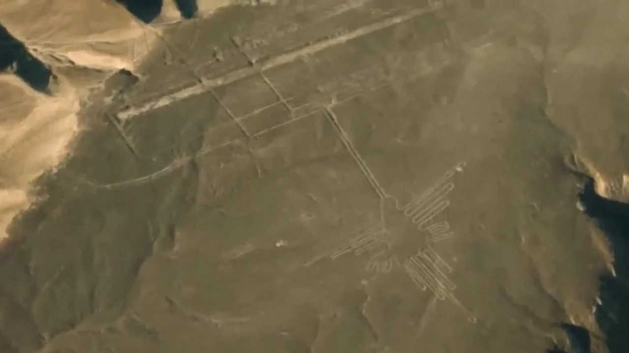
From an aircraft, the Peruvian desert suddenly becomes a drawing surface. Long lines cross the plain, trapezoids widen between hills and animals appear at a scale that no single person on the ground can take in at once. That viewpoint encourages a tempting question: how could anybody make the figures without first flying above them?
But seeing a whole design from one position is not the same as being able to build it. People routinely set out roads, fields, walls and large ceremonial spaces by controlling smaller measurements on the ground. The Nazca problem is therefore not evidence for lost aircraft. It is a problem of layout, labour and coordination, all capabilities that the societies of ancient Peru demonstrably possessed.
The lines are changes in colour, not deeply carved trenches
UNESCO describes a deceptively simple technique. Makers removed the darker, weathered stones that cover the desert surface and exposed lighter material beneath. The resulting contrast produced narrow paths, broad cleared shapes and outlines. The figures did not require cutting hundreds of metres into solid rock or importing a mysterious building material.
The landscape did much of the preserving. The Nazca and Palpa plains receive extremely little rain, and the stable, arid surface allowed shallow marks to remain visible for centuries. That durability can make the work look technologically impossible. In reality, the same environmental conditions that make the desert appear empty also helped preserve evidence of repeated human activity.
A large design can be controlled one segment at a time
A straight line does not require an aerial observer. Two or more ground markers can establish a direction, and repeated measurements can extend it. Curves and proportions can be transferred in sections from a smaller plan, while nearby slopes provide partial views. Those are ordinary geometric possibilities, not proof of one recovered Nazca instruction manual.
Archaeologists do not have a surviving blueprint that explains how every figure was enlarged, and different works need not have followed one recipe. The important limit is logical: an unobstructed view of the completed image is not a prerequisite for controlling the positions of its parts. Careful ground work can produce a form that becomes most legible only at a distance.
Some geoglyphs appear to have addressed people walking nearby
A 2024 study led by Yamagata University and published in the Proceedings of the National Academy of Sciences distinguished two broad patterns among figurative geoglyphs. Large line-type figures, often showing wild animals, were associated with networks of straight lines and trapezoids. The researchers interpreted them in relation to community-level ceremonial activity.
Smaller relief-type figures often showed people, domesticated camelids and severed heads. Many were positioned within viewing distance of winding trails. The authors suggested that these could work like visual messages encountered by individuals or small groups moving through the landscape. That finding turns the airplane question around: at least some figures may have been placed precisely for a ground-level audience.
There is no single proven purpose for every line
The World Heritage property contains thousands of lines and geometric forms as well as images of animals, plants, imaginary beings and people. They were created over many centuries across a large cultural landscape. UNESCO connects them broadly with symbolic, ritual and social functions, but no inscription supplies one neat answer for the entire collection.
Researchers have examined connections with water, movement, pilgrimage, astronomy, community gatherings and sacred places. Some proposals may explain particular features better than others, and meanings could have changed as later communities added to an older landscape. Treating every mark as part of one giant code is less cautious than asking how different types, locations and dates relate to human behaviour.
Computer analysis found possibilities; archaeologists confirmed 303 figures
The desert is still yielding surprises. For the 2024 project, computer analysis searched a vast collection of aerial and geospatial imagery and ranked places that looked promising. Researchers then had to visit those locations, inspect the surface and document what was actually there. In a six-month field survey, the team confirmed 303 additional figurative geoglyphs, nearly doubling the known number in the study area.
It is inaccurate to say that artificial intelligence discovered the figures by itself. The system narrowed an enormous search problem; archaeological fieldwork supplied the confirmation and context. The enlarged dataset then revealed the different relationships between line-type figures, formal line networks, relief-type figures and winding trails. The value was not only more pictures, but a better map of how people may have encountered them.
The real achievement is a landscape organised across generations
Peru's Ministry of Culture has documented geoglyphs linked with traditions that predate the best-known Nazca works, including figures associated with the Paracas culture. The wider record therefore spans more than one community and more than one moment. The desert was not a blank canvas completed in a single project; it was a meaningful landscape revisited and altered across generations.
That long human story is more impressive than the flying-machine myth. People selected routes, coordinated labour, maintained shared meanings and made subtle surface changes that survived because of an extraordinary environment. We can explain how large marks were possible without pretending we know exactly what every one meant. The honest mystery begins after the airplanes are removed from the question.
Sources and further reading
- UNESCO World Heritage Centre: Lines and Geoglyphs of Nasca and Palpa ↗
- Yamagata University: AI-accelerated survey and 303 field-confirmed geoglyphs ↗
- PNAS: AI-accelerated Nazca survey nearly doubles known figurative geoglyphs ↗
- Peru Ministry of Culture: More than 50 newly documented geoglyphs ↗
- Peru Ministry of Culture: Management plan for the Nasca and Palpa heritage area ↗
- NASA Earth Observatory: Nazca Lines, Peru ↗
- Peru Ministry of Culture: Protection action in the Chauchilla sector, 2026 ↗
- Wikimedia Commons: Nazca geoglyph photograph and CC0 dedication ↗
This article was written for Curiosity Desk. We do not copy other publishers or invent quotes. If a material error is found, we correct it openly.
Read the full standards →One answer should lead to a better question
Bring your curiosity to the group
Curious Minds is our public Facebook community for surprising science, strange history, Australian wildlife and everyday questions. No copied posts, no personal-friend invitations and no link dumping.
- Three self-contained discussion prompts each week
- Sourced answers and honest uncertainty
- Respectful conversation without spam