Why water moves a bend sideways
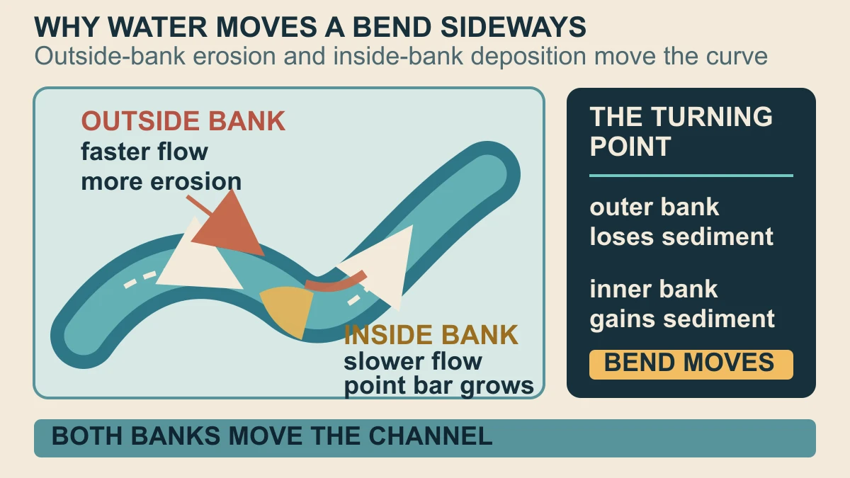
A river bend is not a fixed ornament in the landscape. As water rounds a curve, the fastest and most erosive flow is concentrated toward the outside bank, while the inside of the bend is a lower-energy place where transported sediment can settle. The result is a paired process: one bank is cut back as the other builds outward.
USGS describes this familiar pattern as outside-bend erosion and inside-bend deposition. The inside deposit is called a point bar. This is a useful mechanism, not a promise that every bend changes at the same speed or in the same direction: bank material, discharge, vegetation and the shape of the channel all matter. The point is that once the curve exists, erosion and deposition can reinforce its migration.
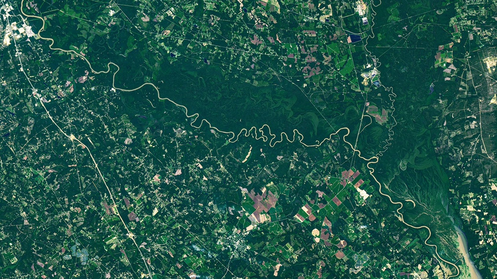
The Congaree image makes the long-term result visible from above. NASA's Landsat 9 scene shows the river winding through a broad forested floodplain, with lighter, curving bands tracing old channels, ridges and swales. Those paleochannels are a record of where the river has been, but the image alone does not measure the age of each channel or the exact flow that created it.
That balance also explains why a river can appear to move sideways without water moving uphill. Flow continually transfers sediment: erosion removes material from the outer bank, while point-bar deposition adds it to the inner bank. Vegetation can stabilize some edges, but it does not turn a channel into a static line. The broad pattern is observed across meandering rivers; the exact shape of Congaree's channel must be read from the cited case study and maps.
How a meander becomes an oxbow lake
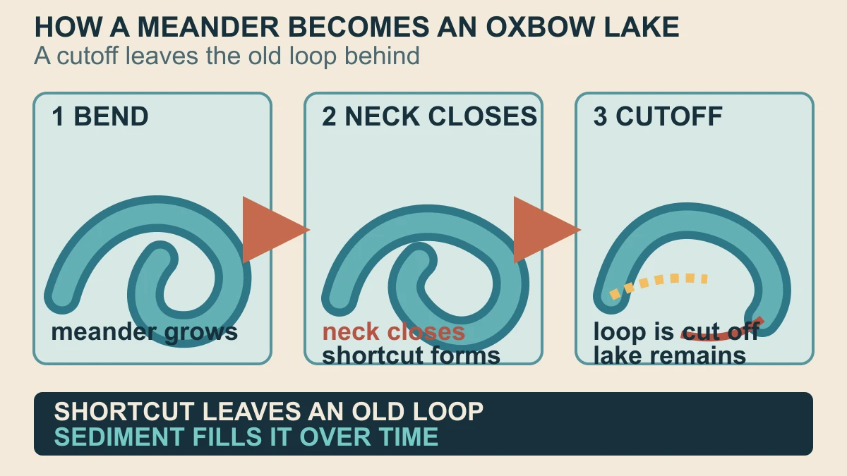
A meander becomes an oxbow when the river finds a shorter route across the narrow neck of its loop. The new channel is straighter, so more of the river's flow takes the shortcut and the former loop is cut off from the main current. USGS EROS describes the separated loop as an oxbow lake and shows the same kind of change through a time series of Landsat images.
The cutoff does not freeze the old loop in place. Water can remain in it, but sediment and organic material continue to arrive, gradually making the basin shallower. USGS describes a longer sequence in which an oxbow fills, becomes a swamp or bog for a time and may eventually dry. In Congaree, USGS identifies several oxbow lakes and says many can fill with sand, clay and peat-rich material before becoming sloughs or semi-perennial wetlands.
This is why the river-shaped marks in NASA's image are more than decorative curves. An active channel, a recently abandoned loop and a sediment-filled wetland can all be parts of one migrating system at different stages. The satellite scene supports that landscape reading; the step-by-step formation and filling mechanism comes from the independent USGS evidence, not from colour alone.
At the neck, a cutoff can happen during a high-flow event or through gradual narrowing; this package does not assign a date to the visible loops. Once the main current bypasses the bend, the loop's connection and water chemistry change. The old waterbody can remain open, receive floodwater, or collect fine sediment and organic matter. That sequence is why oxbow describes a stage in a river landscape, not a permanent label for every curved patch.
Why a few feet can sort a floodplain forest
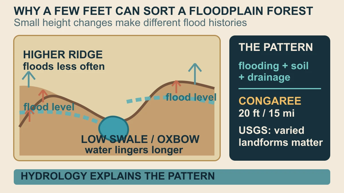
Floodplain forests are sorted by more than distance from the river. A ridge, levee, swale or abandoned channel can sit only a small vertical distance from its neighbour yet experience a different frequency or duration of flooding. USGS research on bottomland forests finds that flooding, groundwater, soil moisture, soil factors and drainage influence which tree communities occupy different parts of a floodplain.
Congaree is unusually flat but not featureless. The USGS geology account says the park has only about 20 feet of elevation change over 15 miles, while its floodplain still contains ridges, levees, deep-water sloughs, oxbow lakes and streams. That small relief changes how water moves and lingers. NPS likewise describes river water carrying nutrients and sediment through the floodplain, supporting the park's bottomland hardwood forest.
The careful conclusion is not that a green shade in one Landsat image identifies a particular tree species. It is that a migrating river builds a patchwork of landforms, and those landforms change the hydrologic conditions that forests experience. Congaree is a vivid case study of that relationship, while the general mechanism remains a source-backed explanation with local details still requiring local measurements.
Elevation is a control on exposure, not a species label. A slightly higher ridge may drain sooner, while a lower swale can hold water longer after a flood. Over many seasons those differences alter soil moisture and the conditions under which different bottomland communities persist. This is the scale at which the image becomes useful: it reveals the arrangement of landforms that field hydrology and ecology must test, rather than replacing those measurements.
Sources and further reading
- NASA Earth Observatory — The Forested Floodplains of Congaree National Park ↗
- USGS — Geology of Congaree National Park ↗
- USGS — Ecology of Congaree National Park ↗
- USGS — Find-A-Feature: Meander ↗
- USGS EROS — Oxbow Lakes ↗
- USGS — Forest and flooding with special reference to the White River and Ouachita River basins ↗
- National Park Service — Congaree National Park ↗
- NASA — Guidelines for using NASA Images and Media ↗
This article was written for Curiosity Desk. We do not copy other publishers or invent quotes. If a material error is found, we correct it openly.
Read the full standards →One answer should lead to a better question
Bring your curiosity to the group
Curious Minds is our public Facebook community for surprising science, strange history, Australian wildlife and everyday questions. No copied posts, no personal-friend invitations and no link dumping.
- Three self-contained discussion prompts each week
- Sourced answers and honest uncertainty
- Respectful conversation without spam