Read the radar image
What the colours and shapes actually represent
- Location
- East Antarctica
- Central feature
- Nunatak Zaterjavshijsja
- Instrument
- NISAR L-band radar
- Data collected
- August 2025
- Magenta
- Mostly smoother ice returns
- Green
- Crevasses and complex scattering
These labels describe NASA and JPL's interpretation of the processed radar measurements, not colours a camera would record.
The hummingbird is real imagery, but it is not a bird
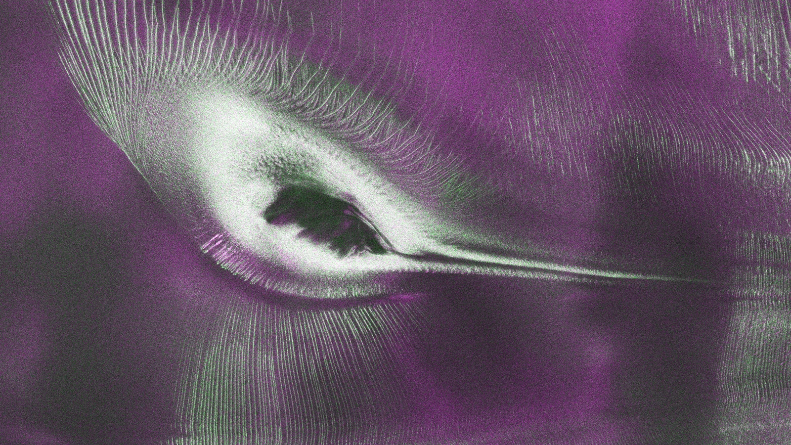
A shape resembling a hummingbird has appeared in a radar view of East Antarctica released by NASA's Jet Propulsion Laboratory. The dark body, long beak and bright fan of feathers are convincing enough to stop a fast scroll. None of them belongs to an animal. The image records a mountain surrounded by moving, heavily fractured ice.
JPL published the image story on 21 July 2026 as NASA and the Indian Space Research Organisation began releasing more data from the NISAR satellite. The measurements behind this scene were gathered by its L-band radar in August 2025 while mission teams were testing the spacecraft. It is genuine Earth-observation data, but it is not an ordinary colour photograph.
The dark body is a mountain emerging through the ice
At the centre-left is Nunatak Zaterjavshijsja, a mountaintop that projects above the surrounding Antarctic ice. A nunatak is an exposed rocky summit or ridge surrounded by a glacier or ice sheet. In this view, the moving ice streams northeast toward the ocean while the rock remains an obstacle in its path.
The resemblance to a bird comes from the meeting of topography and flow. The exposed mountain forms the apparent body. A narrow dark and bright feature extends like a beak, while rows of crevasses spread around it like flight feathers. The nickname describes what human eyes recognise in the pattern; it is not a scientific classification of the landform.
The mountain forces the glacier to reveal its movement
Glacial ice can look fixed during a single human visit, yet it deforms and flows under its own weight. When that moving mass encounters a resistant mountain, the path and speed of the ice cannot remain uniform. Stress builds around the obstruction, and the brittle upper surface fractures into crevasses.
Those fractures outline how the ice is responding. Lines curve around the mountain, open into fans and converge again farther downstream. The image is therefore more than an accidental animal portrait. It is a map of motion written by the glacier itself, with the nunatak acting as the object that makes the otherwise subtle flow pattern visible.
Green does not mean the Antarctic ice is green
The magenta, green and white colours were assigned while processing radar measurements. NISAR transmitted microwave signals with a horizontal polarization, meaning the electric field of the wave oscillated in a particular orientation. The instrument then measured the orientation and strength of the echoes that returned.
A signal that returned mainly with horizontal polarization was more likely to have bounced from a comparatively regular surface such as smoother ice. Those returns appear magenta. The colour is a visual key for a type of echo, not a claim about pigment, algae or coloured snow on the ground.
The green feathers are a signature of fractured ice
Some signals returned with vertical polarization after entering snow or ice, refracting, or scattering from irregular surfaces such as crevasse faces. Scientists call the more complicated interaction volume scattering. JPL displayed these returns in green, turning the cracked zones into the hummingbird's most dramatic feature.
White areas are places where the magenta and green components both scatter back strongly. JPL says this may indicate a more even blend of surface and volume scattering. The image does not translate each coloured pixel into one perfectly identified object, but it does separate physical interactions that a normal photograph combines into a nearly uniform field of white.
An optical satellite sees a much quieter scene
JPL compared the radar view with a Landsat 9 optical image taken in November 2025. In visible light, the same landscape is almost entirely white. Shadows and faint texture reveal the nunatak and uneven ice, but the enormous feather-like fracture pattern is much harder to read.
That contrast explains the value of radar. Visible-light cameras record sunlight reflected from a surface. NISAR sends out its own microwave energy and measures the returning echo. Its longer-wavelength L-band signal can interact with material below the immediate snowy surface, exposing structure that is weak or hidden in an optical view.
NISAR is listening for echoes from a changing planet
NISAR stands for NASA-ISRO Synthetic Aperture Radar. Synthetic aperture radar combines measurements gathered as a spacecraft moves along its orbit to produce detailed ground images. Because it supplies the signal itself, it can observe through darkness and many cloud conditions that would block a conventional view.
The mission carries both L-band and S-band radar systems, the first free-flying space mission to use that combination. The longer L-band wavelength can penetrate forest canopies to reveal the ground below, while S-band responds differently to vegetation and surface structure. This Antarctic image uses the L-band instrument supplied by JPL.
The public data release matters more than one beautiful picture
NASA began continuously releasing calibrated products for L-band measurements on 20 July 2026, while ISRO distributes S-band observations through its own portal. NISAR is designed to revisit nearly all of Earth's land and ice-covered surfaces twice every twelve days, creating repeated measurements rather than a collection of isolated postcards.
Researchers can use those repeat views to study the movement of ice and land, changes in forests and wetlands, and the effects of hazards such as earthquakes and landslides. A single false-colour scene cannot establish a long-term trend. Its scientific power grows when it is compared with later observations made by the same instruments.
The right way to share the viral image
Three labels keep the story honest. It is radar rather than a visible-light photograph, the colours encode different signal returns, and the hummingbird is a resemblance created by rock, flowing ice and crevasses. Removing any of those details turns a remarkable measurement into a misleading mystery.
The real explanation is more curious than a fake discovery. A mountain that barely changes at human scale is forcing an ice stream to bend and break around it. A satellite hears the difference in microwave echoes, scientists translate those echoes into colour, and the resulting map lets the human brain find a bird in the mechanics of a glacier.
Sources and further reading
This article was written for Curiosity Desk. We do not copy other publishers or invent quotes. If a material error is found, we correct it openly.
Read the full standards →One answer should lead to a better question
Bring your curiosity to the group
Curious Minds is our public Facebook community for surprising science, strange history, Australian wildlife and everyday questions. No copied posts, no personal-friend invitations and no link dumping.
- Three self-contained discussion prompts each week
- Sourced answers and honest uncertainty
- Respectful conversation without spam